


: Level D")


|
By clicking Subscribe, I agree to receive advertising and other marketing messages from Logisticus Technologies LLC under the terms of the Privacy Policy and User Agreement. |
|
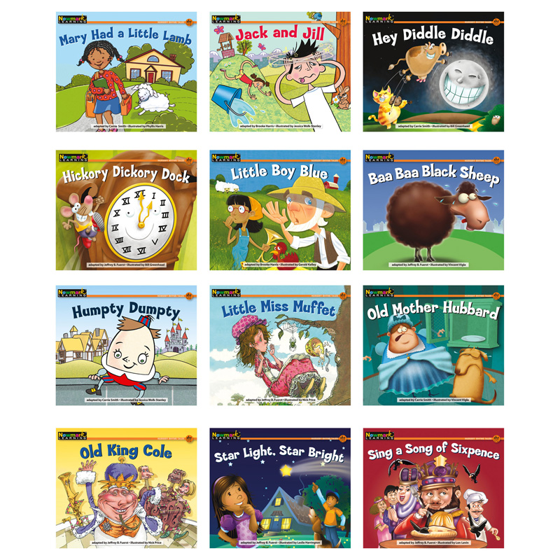
Newmark Learning Nursery Rhyme Tales Content-Area Leveled Reader, English, Set of 12
(Contains 12 Books)
| $47.88 | Retail $62.00 |
- As required by the Common Core State Standards, Rising Readers steadily increase in reading level complexity while integrating nonfiction and fiction content instruction
- Children will love the gorgeous photos or illustrations, fun topics, and BONUS comprehension skills and sight word activities
- Interactive CD-ROMs for whiteboards or computers motivate students to learn core content and literacy skills
- Customized teacher/parent tips and after-reading activities included
Manufacturer:
Newmark Learning
Item:
NL-0440
UPC Code:
9781607193401
Our Part #
NL-0440
Condition
New
$47.88PD
$62.00
$62.00
Availability
In Stock
You may be also interested
Product description
Expertly researched and designed, National Geographic's World Wall Map is the authoritative map of the world by which other reference maps are measured. Colorful Decorator style map with vibrant color palette that fills each country for easy identification. Background shows mountain ranges and valleys in subtle shaded relief with mountain ranges labeled. Major water bodies including rivers, lakes, glaciers, oceans, seas, gulfs, bays, straits, and bathymetry. Clearly defined international boundaries, cities, islands, airports, and physical features. Thousands of place names carefully and artfully placed to maintain legibility in heavily populated areas. Up-to-date international boundaries and territorial control reflect de facto status on the ground. Meticulously researched using multiple authoritative sources including the U.N., U.S. Board on Geographic Names, and policies of individual governments. Accurate place names use a combination of conventional English names, official national names, and standard transliterations for non-Latin alphabets. Drawn in Winkel Tripel projection with distortions minimized unlike other World maps (e.g. Greenland is shown the same size as Argentina, not South America). Corner inset maps feature vegetation, land use, population density, and north and south polar regions. The map is encapsulated in heavy-duty 1.6 mil laminate which makes the paper much more durable and resistant to the swelling and shrinking caused by changes in humidity. Laminated maps can be framed without the need for glass, so the frames can be much lighter and less expensive.
Specifications
Barcode Dimension
9781607193401
Barcode Dimension
9781607193401
Barcode Dimension
9781607193401
Barcode Dimension
9781607193401
Barcode Dimension
9781607193401
Barcode Dimension
9781607193401
Barcode Dimension
9781607193401
Copy speed (color normal quality A3)
9781607193401
Age Group
4-6 years
Battery Included
N
Contains Eggs
N
Contains Fish
12
Contains Sesame
'9781607193401
Contains Wheat
7.63" x 6.5" x 2"
Height
1.5
Length
7
Material
USA
Material
Paper
Pocket Details
Grade PK-1
Product Type
Leveled Readers
Sharp Points or Edges
Multi
Sheet Color(s)
N
Weight
1.31
Width
6.5